UPSC – CSE Prelims 2024
EASY
GEOGRAPHY – WORLD
1. Which of the following countries are well known as the two largest cocoa producers in the world?
(a) Algeria and Morocco
(b) Botswana and Namibia
(c) Côte d’Ivoire and Ghana
(d) Madagascar and Mozambique
Ans. (c)
About 70 percent of the world’s cocoa beans come from four West African countries: Ivory Coast, Ghana, Nigeria and Cameroon.
The Ivory Coast and Ghana are by far the two largest producers of cocoa, accounting for more than 50 percent of the world´s cocoa.
UPSC – CSE Prelims 2023
GEOGRAPHY – WORLD
1. About three-fourths of world’s cobalt, a metal required for the manufacture of batteries for electric motor vehicles, is produced by –
(a) Argentina
(b) Botswana
(c) Democratic Republic of the Congo
(d) Kazakhstan
Ans: C
About three-fourths of the world’s cobalt, a metal required for the manufacture of batteries for electric motor vehicles, is produced by (c) Democratic Republic of the Congo.
The Democratic Republic of the Congo is the largest producer of cobalt globally, accounting for a significant portion of the world’s cobalt supply. Cobalt is a critical component in the production of lithium-ion batteries, which are widely used in electric vehicles and various electronic devices. The country’s rich reserves and favorable geological conditions make it a major player in the global cobalt market.
GEOGRAPHY – WORLD
2. Consider the following statements:
Statement-I: Switzerland is one of the leading exporters of gold in terms of value.
Statement-II: Switzerland has the second largest gold reserves in the world.
Which one of the following is correct in respect of the above statements?
(a) Both Statement-I and Statement-II are correct and Statement-II is the correct explanation for Statement-I
(b) Both Statement-I and Statement-II are correct and Statement-II is not the correct explanation for Statement-I
(c) Statement-I is correct Statement-II is incorrect
(d) Statement-I is incorrect Statement-II is correct
Answer : C
According to several organisations, Switzerland is consistently the world’s leading gold exporting country based on value. Hence statement 1 is correct.
According to several organisations, USA has the highest gold reserves followed by Germany. Hence statement 2 is incorrect.
GEOGRAPHY – WORLD
3. Which one of the following is a part of the Congo Basin?
(a) Cameroon
(b) Nigeria
(c) South Sudan
(d) Uganda
Ans: A
The Congo Basin spans across six countries—Cameroon, Central African Republic, Democratic Republic of the Congo, Republic of the Congo, Equatorial Guinea and Gabon.
Hence, option A is correct.
UPSC – CSE Prelims 2022
GEOGRAPHY – WORLD LAKE
1. Which one of the following lakes of west Africa has become dry and turned into a desert?
- Lake Victoria
- Lake Faguibine
- Lake Oguta
- Lake Volta
Ans. B
- Lake Faguibine
- It is an isolated lake in Mali, west of Timbuktu (Tombouctou).
- It lies north of the Niger River in the Macina depression, and it is reached by branches of Niger in times of flood.
- At high water, it reaches a length of about 50 miles (80 km).
- One example of increasing aridity in Mali appears in Lake Faguibine.
- These false-colour Landsat satellite images of the lake show how it changed over the decades.
- Lake Faguibine has experienced widely fluctuating water levels since the turn of the twentieth century but, at its fullest, has ranked among the largest lakes in West Africa.
- In 1974, this lake covered roughly 590 square kilometres (230 square miles).
- Starting in the late 1980s, a drop in precipitation steadily dried the lake.
- By the late 1990s, the traditional livelihoods of fishing, agriculture, and livestock herding became impractical. Even though normal rainfall resumed after the year 2000, the lake remained nearly dry. Hence, Option 2 is correct.
GEOGRAPHY – WORLD
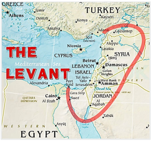
2. The term “Levant” often heard in the news roughly corresponds to which of the following regions?
(a) Region along the eastern Mediterranean shores
(b) Region along North African shores stretching from Egypt to Morocco
(c) Region along Persian Gulf and Horn of Africa
(d) The entire coastal areas of Mediterranean Sea
Ans. A
Levant Region:
- It is an approximate historical geographical term referring to a large area in the Eastern Mediterranean region of Western Asia. Hence, Option 1 is correct.
- In its narrowest sense, which is in use today in archaeology and other cultural contexts, it is equivalent to a stretch of land bordering the Mediterranean in southwestern Asia, i.e. the historical region of Syria (“greater Syria”), which includes present-day Syria, Lebanon, Jordan, Israel, Palestine and most of Turkey southwest of the middle Euphrates.
- Its overwhelming characteristic is that it represents the land bridge between Africa and Eurasia.
- The Levant has been described as the crossroads of western Asia, the eastern Mediterranean and northeast Africa.
- The name Levant States was given to the French mandate of Syria and Lebanon after World War I, and the term is sometimes still used for those two countries, which became independent in 1946. A similar term, Al-Mashriq (“Where the Sun Rises”), exists in Arabic, although this term refers to a broader geographic region.
UPSC – CSE Prelims 2020
GEOGRAPHY – WORLD
1. Consider the following pairs:
River Flows into
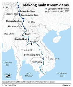
- Mekong – Andaman Sea
- Thames – Irish Sea
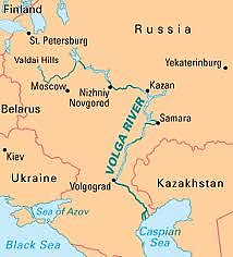
- Volga – Caspian Sea
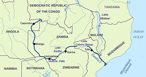
- Zambezi – Indian Ocean
Which of the pairs given above is/are correctly matched?
(a) 1 and 2 only
(b) 3 only
(c) 3 and 4 only
(d) 1,2 and 4 only
Ans: (a)
Explanation:
- Mekong River forms the Mekong delta and flows into South China sea
- Thames flows into the North Sea

UPSC – CSE Prelims 2019
GEOGRAPHY – WORLD
1. Consider the following pairs
Sea | Bordering Country |
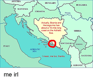
1. Adriatic Sea | Albania |
2. Black Sea | Croatia |
3. Caspian Sea | Kazakhstan |
4. Mediterranean Sea | Morocco |
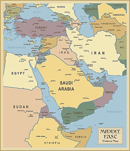
5. Red Sea | Syria |
Which of the pair given above are correctly matched?
(a) 1, 2 and 4 only (b) 1, 3 and 4 only
(c) 2 and 5 only (d) 1, 2, 3, 4 and 5
Ans: (b)
UPSC – CSE Prelims 2018
GEOGRAPHY – WORLD
1. Which of the following has/have shrunk immensely/dried up in the recent past due to human activities?
- Aral Sea
- Black Sea
- Lake Baikal
Select the correct answer using the code given below:
(a) 1 only
(b) 2 and 3
(c) 2 only
(d) 1 and 3
Ans: (a)
Aral Sea
- The Aral Sea was an endorheic lake (one with no outflow) lying between Kazakhstan in the north and Uzbekistan in the south.
- The name roughly translates as “Sea of Islands”, referring to over 1,100 islands that had dotted its waters.
- Formerly one of the four largest lakes in the world with an area of 68,000 km2, the Aral Sea has been shrinking since the 1960s after the rivers that fed it were diverted by Soviet irrigation projects.
- By 1997, it had declined to 10% of its original size, splitting into four lakes.
- By 2009, the southeastern lake had disappeared and the southwestern lake had retreated to a thin strip at the western edge of the former southern sea; in subsequent years, occasional water flows have led to the southeastern lake sometimes being replenished to a small degree.
- The shrinking of the Aral Sea has been called “one of the planet’s worst environmental disasters“.
Lake Baikal
- It is a rift lake located in southern Siberia, Russia.
- Baikal means in Mongolian, “the Nature Lake”
- Lake Baikal is the largest freshwater lake by volume in the world, containing 22–23% of the world’s fresh surface water.[
- With a maximum depth of 1,642 m (5,387 ft), Baikal is the world’s deepest lake.
- Like Lake Tanganyika, Lake Baikal was formed as an ancient rift valley, having the typical long, crescent shape.
- Baikal is home to thousands of species of plants and animals, many of which exist nowhere else in the world.
- The lake was declared a UNESCO World Heritage Site in 1996.
In 2014, for the first time over the past 60 years the water level in the lake Baikal dropped by 40 centimeters to almost a critical level – 456.09 meters.
