UPSC – CSE Prelims 2024
MEDIUM
GEOGRAPHY – MAPPING – INDIA
1. Consider the following information:
Waterfall | Region | River | |
1. | Dhuandhar | Malwa | Narmada |
2. | Hundru | Chota Nagpur | Subarnarekha |
3. | Gersoppa | Western Ghats | Netravati |
(a) Only one
(b) Only two
(c) All three
(d) None
Ans. (a)
Only pair 2 is correct
Waterfall | Region | River | |
1. | Dhuandhar | Jabalpur | Narmada |
2. | Hundru | Chota Nagpur | Subarnarekha |
3. | Gersoppa | Western Ghats | Sharavathi |
NCERT Test Geography Class VI : Chp – 6 (Major Landforms of the Earth) Identify the waterfalls of plateau areas from the following waterfalls: 1. Hundru falls 2. Jog falls 3. Shivanasamudra falls 4. Dhuandhar falls Select the correct answer from the codes given below: (a) 1 only (b) 2 and 3 only (c) 1 and 2 only (d) 3 and 4 only Ans. (c)
Source: Geography Class VI : Chp – 6 (Major Landforms of the Earth) |
UPSC – CSE Prelims 2020
GEOGRAPHY – MAPPING – INDIA
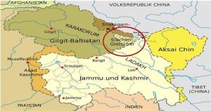
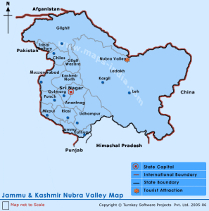
1. Siachen Glacier is situated to the
(a) East of Aksai Chin
(b) East of Leh
(c) North of Gilgit
(d) North of Nubra Valley
Ans: (d)
Explanation:
UPSC – CSE Prelims 2017
GEOGRAPHY – MAPPING – INDIA
1. With reference to river Teesta, consider the following statements :
- The source of river Teesta is the same as that of Brahmaputra but it flows through Sikkim.
- River Rangeet originates in Sikkim and it is a tributary of river Teesta.
- River Teesta flows into Bay of Bengal on the border of India and Bangladesh.
Which of the statements given above is/are correct ?
(a) 1 and 3 only
(b) 2 only
(c) 2 and 3 only
(d) 1, 2 and 3
Ans: (b)
The correct answer is 2 only.
- Teesta River originates from the Pahunri glacier (not from the same source as the Brahmaputra). So statement 1 is incorrect.
- The Brahmaputra originates in the Angsi glacier near Mount Kailash.
- Teesta is one of the right tributaries of Brahmaputra.
- Before going to the Bay of Bengal through Bangladesh Teesta flows through West Bengal and Sikkim. So statement 3 is incorrect.
- River Rangeet originates in Sikkim which is the largest river in Sikkim and also a tributary of river Teesta. So statement 2 is correct.
Tributaries of Brahmaputra:
Left | Right |
|
|
GEOGRAPHY – MAPPING – INDIA
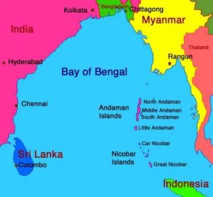
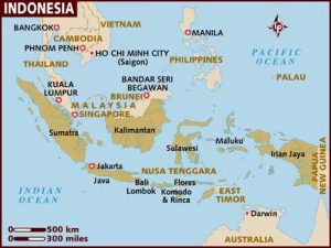
2. Which of the following is geographically closest to Great Nicobar?
(a) Sumatra
(b) Borneo
(c) Java
(d) Sri Lanka
Ans: (a)
GEOGRAPHY – MAPPING – INDIA
3. From the ecological point of view, which one of the following assumes importance in being a good link between the Eastern Ghats and the Western Ghats?
(a) Sathyamangalam Tiger Reserve
(b) Nallamala Forest
(c) Nagarhole National Park
(d) Seshachalam Biosphere Reserve
Ans: (a)
Sathyamangalam forest rangeis a significant wildlife corridor in the Nilgiri Biosphere Reserve between the Western Ghats and the rest of the Eastern Ghats and a genetic link between the four other protected areas which it adjoins, including the BilligirirangaSwamy Temple Wildlife Sanctuary, Sigur Plateau, Mudumalai National Park and Bandipur National Park.
GEOGRAPHY – MAPPING – INDIA
4. Consider the following statements:
- In India, the Himalayas are spread over five States only.
- Western Ghats are spread over five States only.
- Pulicat Lake is spread over two States only.
Which of the statements given above is/are correct?
(a) 1 and 2 only
(b) 3 only
(c) 2 and 3 only
(d) l and 3 only
Ans: (b)
The Indian Himalayan Region (IHR) is the section of the Himalayas within India, spanning the states of Jammu & Kashmir, Himachal Pradesh, Uttarakhand, Sikkim, Arunachal Pradesh, as well as the hill regions of two states – Assam and West Bengal.
Western Ghats are a chain of mountains running parallel to India’s western coast, approximately 30-50 km inland.
The Western Ghats traverse the States of Kerala, Tamil Nadu, Karnataka, Goa, Maharashtra and Gujarat.
Pulicat Lake formerly PralayaKaveri is the second largest brackish water lake or lagoon in India, after Chilika Lake. It straddles the border of Andhra Pradesh and Tamil Nadu states with over 40% of it in Andhra Pradesh and 60% in Tamil Nadu situated on the Coromandal Coast in South India. The lake encompasses the Pulicat Lake Bird Sanctuary. The barrier island of Sriharikota separates the lake from the Bay of Bengal and is home to the SatishDhawan Space Centre.
GEOGRAPHY – MAPPING – INDIA
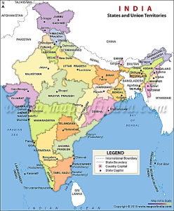
5. If you travel by road from Kohima to Kottayam, what is the minimum number of States within India through which you can travel, including the origin and the destination?
(a) 6
(b) 7
(c) 8
(d) 9
Ans: (b)
GEOGRAPHY – MAPPING – INDIA
6. At one of the places in India, if you stand on the seashore and watch the sea, you will find that the sea water recedes from the shore line a few kilometres and comes back to the shore. Twice a day and you can actually walk on the sea floor when the water recedes. This unique phenomenon is seen at
(a) Bhavnagar
(b) Bheemunipatnam
(c) Chandipur
(d) Nagapattinam
Ans: (c)
A unique phenomenon rarely seen anywhere else, the sea recedes by as much as five kilometres every day on the Chandipur beach in eastern India, not just enthralling the onlooker but also offering an opportunity to literally walk into the sea.
One of nature’s many wonders, the sea recedes massively from the beach during ebb and returns to fill the emptiness during high tide. This hide-and-seek of the sea comes to play twice a day and seeing the sea disappear and then return is an unforgettable experience.
Chandipur lies around 200 km from state capital Bhubaneswar.
The Chandipur beach is also well known for its proximity to the Defence Research and Development Organisation’s (DRDO) Integrated Test Range.
